


1. Agios Nikolaos
Protected Historical Monument - ΦΕΚ 666/Β/23-9-1970

2. Finikas Sfakia
Finikas (or Phoenix) is a pin on the map in the province of Sfakia, Crete. Located in a small bay about 700 meters west of Loutro, the tiny coastal village is named after the ancient town of Phoenix, ruins of which can still be found near Loutro. It has a small pebbled beach, organized with plenty of sunbeds and a shower, and a small port from where you can take boat trips to Marmara beach. The backdrop is bleak Cretan Mountain scenery littered with small white churches. Nothing much happens here apart from the occasional departure of a water taxi and that’s the way most people like it. Right on the beach, there is a tavern with local food and several rooms to rent, almost all with nice views of the bay.
The village is crossed by the European E4 hiking trail which connects Marmara beach with Loutro. Finikas is a great place if you want to relax and explore the surrounding area. It offers tranquility, many hiking options and access to some of the most picturesque villages and stunning beaches of southern Crete. The more adventurous can spend a couple of hours in the early morning walking up the hill to Liviniana and then down the Aradena Gorge, the rest can just wander to Loutro for breakfast or a nice meal. The village can be accessed either through a dirt track from the village of Livaniana or by boat or on foot from Loutro, yet driving from Livaniana is not recommended. So, if you're looking for simple relaxation - sunbathing, reading, walking and swimming this is a great place.

3. Aradena

4. Kalami
Kalami is a settlement located in the southeastern part of the Municipality of Viannos in the homonymous province of the Prefecture of Heraklion. It is far away 78 km by road from Heraklion, 14 km from Ano Vianno (capital of the Municipality) and 31 km from Ierapetra. The main church is of Agios Georgios.
The village is built on the edge of a small basin at an altitude of 480 meters, which today stands deserted and abandoned. The cameraman Nikos Sarantos had recorded with his camera the "eerie" environment of the village. He made a documentary about the area entitled: "Kalami, the face of abandonment". In 2016, it was screened at the Los Angeles Film Festival.
History
Kalami was probably built at the end of the Venetian occupation and the beginning of the Turkish occupation. Natural factors, mainly reasons for protection from enemy attacks, contributed to its construction in a semi-mountainous area. Thus, while it is close to the sea, it is not visible for security reasons. This is happening in most of the villages in the municipality, because they were afraid of the various pirates of the Mediterranean, who were looting and committing acts of violence against the inhabitants of the coastal areas. So they wanted their villages not to have visual contact with the sea.
In the place of today's church of the village, Agios Georgios and Charalambos, where the Christians of the surrounding villages used to go secretly to pray, the first houses were built next to it. Later, more and more people came to live in Kalami, which began to grow and expand slowly. The main occupations of the people of Kalamia revolved around the cultivation of olive trees, cereals, fruit trees, mainly citrus, carob, vines and to a lesser extent engaged in animal husbandry. All their occupations were aimed at meeting the needs of their families. The development of the living standards of the inhabitants began after 1960, when the occupations turned to the cultivation of early vegetables and banana cultivation.
Kalami, as the main center of residence of the rural population, like most mountainous settlements, was of secondary importance during the winter months mainly and had given the first place to the winter settlements (winter), which were lower and with milder climatic conditions.
Thus, in the whole municipality there were the so-called "metochia", micro-settlements that were used seasonally for the cultivation of the land and the harvest of fruits. The most important shares were Vigles, Skafidia, Psari Forada, Roussos Lakkos, Pente Petres etc. These were mainly used for growing cereals and picking olives. In fact, there were many olive mills (plowshares) for grinding olives.
Under the Aleppo Convention (1878), the villagers were able to obtain rights after the creation of a semi-autonomous province with special privileges (exemption from certain taxes, the right to education, religion, etc.). In 1879, Kalami acquired a school, which until the last years it functioned, until it was abolished in 1987. Also until 1916 in the church of the village were housed two parishes, with priests the brothers Antonis and Grigoris Mavrakis. In fact, on the feast of St. George, one year the festival took place in one parish (upper neighborhood) and the next in the other parish (lower neighborhood), with a special splendor.
Kalami flourished in the 1930s (until the German occupation). It was the most developed shopping center in the municipality. On the beach of Psari Forada, since 1920, there was a customs office as well as seven warehouses (shops), where ships came to unload and load goods of various kinds throughout the municipality. The goods were transported by animals, through Kalamio and reached Arkalochori.
In 1929 the first diesel-powered oil mill was built in the village. This factory was a station of progress and the area that was and is olive production, produced olive oil with a new system and comfort. In 1931, a second, this time water-powered, oil mill was established, because only one was not enough for the needs of the inhabitants. At the same time, there was a water-powered flour mill.
The professions of all kinds have also flourished, many of which have now disappeared. A special place was occupied by the grocery store that sold, among other things, fine fabrics from Athens and Heraklion and people from all over the municipality came to shop. During the years of German occupation, the entire municipality of Viannos experienced the disaster.
In 1949, a reconstruction team arrived in Kalami, consisting of five Swiss, who built many damaged houses. However, the most important project that took place in the area at that time was the construction of an aqueduct with iron pipes and a cement plant. In the same year, the Viannos-Sykologos carriage road was opened. In 1952, the Sykologos-Gdochios road was opened and the village and Ierapetra communicated by road. Until then, the only road to Ierapetra was a cobblestone path built during the Turkish occupation. The road network for Heraklion and Ierapetra improved after the 1960s, when roads to Kalami were asphalted.
Today, the image that Kalami presents has strong signs of desolation. Most of the houses are abandoned, because their inhabitants have relocated to the coastal settlements with a focus on Psari Forada (Sidonia). The official census of 2001 states that Kalami had 44 inhabitants that year. The view of the village is narrow, with a direction from east to west. The roads are very narrow and cobbled and do not allow car traffic. Cars pass only through the ring road of the village.

5. Pano Perivolakia

6. Archanes
Archanes or Epano Archanes is a picturesque small town, built at an altitude of 380 meters in the middle of a basin that it is crossed by Kaeratos stream, dividing it into two parts. It is located at the northeastern tip of the valley formed by Mount Yuchta, which has an altitude of 811 m. Archanes is 14 kilometers away from the city of Heraklion and only 7 kilometers from the Palace of Knossos. The colorful village has been prized by the European Union as model for residential development.
The main hamlet is today called Epano Archanes and stands separate from the quarter of Kato Archanes, which is one km to the north. Archanes has preserved its ancient Greek name, which can be found on a 5th century B.C. inscription. It is an alliance treaty between Knossos and Tylissos, and one of the provisions mentioned, “Archos will have the sanctuary in Acharna”. Archos was a local hero worshipped in Archanes. Archaeological testimony confirms the village’s inhabitation in prehistoric times and throughout history.
The valley and the whole area of Archanes is mostly a vast vineyard, producing the famous sultana grapes. The main products of Archanes are raisins - sultana, excellent quality wine from various varieties (local: kotsifali, mandilari, liatiko, vilana and other newly introduced) and also excellent quality olive oil. Also, aromatic plants are cultivated: dittany, thyme, sage.
History
When the Ottomans, after 22 years’ siege, managed to conquer the Venetian Chandax (Heraklion) in 1669, they gave the city as a gift to A. Baroci, the person who had betrayed it. Archanes became the stronghold of the rebels/guerrilla fighters. In the times of the Cretan State, the city flourished: wine, raisins and olive oil were exported and brought wealth to the city.
The well-to-do Archanians, wanting to express their love and desire to unite with Greece, built houses in the neoclassical style. Their mansion facades adopted an architectural trend imported from liberated Greece. This is how a unique hamlet of architectural interest was created, which has been preserved in its entirety.
Extensive pedestrianisation, picturesque cobblestone lanes, lamp posts and beautifully restored mansions give visitors to Archanes the opportunity to travel back in time. Christian churches decorated with murals coexist with fountains and wonderful buildings from the Ottoman era, the best one among them being Mustafa Naili Pasha’s residence, with fountains and gardens. On the north side of the valley is the quaint gorge named Paradeisi (small Paradise), which the Ottomans called Akarsular Dag (Mountain of the Running Waters).
Within the same gorge, at Pelekita location, there is a water spring; in 1628, Fransesco Morosini channelled its waters to supply Heraklion. The spring is dry today because of water drilling projects in the area.
The town of Archanes was an important revolutionary centre of Eastern Crete during the 1897 Revolution. It was here that, as of February 1897, the Defense Committee of Archanes undertook the responsibility of coordinating military action in the broader region and Eastern Crete in general and faced major attacks by pro-Ottoman Cretans and the regular Ottoman army with remarkable bravery. In essence, the military part of the Cretan Question was decided in the region of Heraklion, centred round the town of Archanes, since the local geology makes it a natural fort, ideal, as proven later, to become the base of guerrilla fighters.
Indeed, the celebration of the 15th of March in 1897 (Commemorating the onset of the Greek Liberation War against the Ottomans) was grand, in this, first, and only, liberated part of Crete, i.e. Archanes, with no presence of Ottoman Occupation troops.
The location of Archanes and the bravery and spirit of its inhabitants were the main factors for the active participation of the village in war events of the 20th century. During the Battle of Crete (May 1941 - WWII) the Command Centre of the Greek Forces was established in Archanes, where a rudimentary military hospital was also established. In the first year of the Nazi Occupation, the first Intelligence task force on Crete was organised in Archanes, offering great services to the Resistance. The presence of the Occupation Forces was particularly strong in Archanes, since it was the seat of the Nazi Military Division.
Protected Historical Monument - ΦΕΚ 666/Β/23-9-1970

7. Matala
Matala, Crete is a popular destination on the Bay of Messara, in the southern part of the Greek island. Matala may only be a tiny village but it is world famous, thanks to the hippies who lived there from the end of the 60s and into the 70s. Among them was Janis Joplin, Joan Baez and Bob Dylan. "Life is today, tomorrow never comes”. That’s one of the many signs you can read when you reach the tiny village. The caves carved into the north face of the coast that remained empty for thousands of years, became the meeting point of the young people of the time who formed the hippie commune and praised their independence from the conservative society and the acquisition of material goods. Some of them lived in the caves of Matala for weeks, months or even years, experimented with sex and hallucinogenic substances while enjoying the beautiful beach with its crystal-clear blue waters. However, the society was still very conservative and some people revolted against the hippies. They were finally driven out by the church in 1977 and the caves closed.
Matala was nothing but a small fishing village up until that time. Back then, there were only a few houses and one tavern. Now, it is a popular holiday destination in Crete. Although hippies no longer live in the caves, thousands of tourists from all over the world, visit the legendary village every summer in order to feel its vibe and connect with the hippie side of Crete. The place still retains the charm of the past and the relaxed lifestyle. It has a lovely fairly long and wide beach but tends to get very crowded too almost in every season. Visitors can find all kinds of accommodation, tavernas, bars and gift shops. Matala is ideal for those who want to spend their holidays near lovely beaches, important archeological sites and traditional villages like Sivas and Kamilari. For those who are interested in Greek history, the Minoan Palace of Phaistos, Agia Triada and the ancient city of Gortys are very close. Matala is located 71 km from the city of Heraklion and getting there is very easy. Local buses also run daily connecting the village with Heraklion and the other villages in the area. So, if you are one of those who love listening to the Joni Michell’s song “Carey” travelling down the deep blue Matala Sea this is the place to spend your holiday.
HISTORY
Matala has a long history dating back to the Neolithic times. At that time, the prehistoric inhabitants of the island sculpted the rocks of the area. It is believed that the famous caves originally used as prehistoric living spaces and places of worship and centuries later as tombs. Matala was also the ancient port of Phaistos during the Minoan period and the port of Gortys during the Roman period when Gortys was proclaimed capital of Crete by the Romans. Ruins of the ancient city can still be seen on the sea bed. Today, Matala caves have been fenced, protected by the Archaeological Service and are accessible to tourists but no one is allowed to live there or stay overnight.
Lyrics from the song Carey by Joni Mitchell
The wind is in from Africa
Last night I couldn't sleep
Oh, you know it sure is hard to leave here Carey
But it's really not my home
My fingernails are filthy, I got beach tar on my feet
And I miss my clean white linen and my fancy French cologne
Oh Carey get out your cane
And I'll put on some silver
Oh you're a mean old Daddy
But I like you fine
Come on down to the Mermaid Café and I will
Buy you a bottle of wine
And we'll laugh and toast to nothing and smash our empty glasses down
Let's have a round for these freaks and these soldiers
A round for these friends of mine
Let's have another round for the bright red devil
Who keeps me in this tourist town
Come on Carey get out your cane
I'll put on some silver
Oh you're a mean old Daddy
But I like you
Maybe I'll go to Amsterdam
Maybe I'll go to Rome
And rent me a grand piano
And put some flowers 'round my room
But let's not talk about fare-thee-wells now
The night is a starry dome
And they're playin' that scratchy rock and roll
Beneath the Matala Moon
Come on Carey get out your cane
I'll put on some silver
We'll go to the Mermaid Café
Have fun tonight
The wind is in from Africa
Last night I couldn't sleep
Oh you know it sure is hard to leave here
But it's really not my home
Maybe it's been too long a time
Since I was scramblin' down in the street
Now they got me used to that clean white linen
And that fancy French cologne
Oh Carey get out your cane
I'll put on my finest silver
We'll go to the Mermaid Café
Have fun tonight
I said, Oh, you're a mean old Daddy but I like you
But you're out of sight

8. Sfentili
The village of Sfentili is located 39 kilometers away from Heraklion in Crete, not far way from Hersonissos. Sfentili is within the confines of the artificial lake of Aposelemis Dam which was constructed in order to solve the vital needs for water supply and irrigation in the north part of eastern Crete, specifically from Heraklion to Agios Nikolaos, Lasithi. The residents of the village, should have left their properties many years ago and for that reason they had been compensated by the state. However, the residents claim that the state should have taken care of the relocation of the settlement to another area, which has not been done and so they stubbornly refuse to leave the place where they were born and raised. As the water level of the dam goes up and down, Sfentyli disappears and appears, making the village a tourist attraction.
Sfentili is at an altitude of 210 meters and the earliest evidence of the existence of the village dates back to 1577, on the list of Fr. Barozzi. In 1583 it is referred as Sfendigli with 78 residents. In the first Turkish census (1671) the settlement (Isfendil) has 9 Christian families. In the census of 1881 it belonged to the Municipality of Mohos, in 1900 it is listed in the Municipality of Lagada and since 1920 in the rural Municipality of Potamia, and in the community of Potamia since 1928.
The name of the settlement is antroponymous. The family name Sfendilos is testified in Crete and surely its first inhabitant would have had this name. During the years of Venetian rule, it was a fief of the Latin diocese of Hersonissos as early as 1248. Recently, 65 skeletons were found in the area, by archaeologist Athanasia Kanda, which according to research may come from a Minoan cemetery.

9. Etia
.jpg)
10. Kritsa
Kritsa is one of the largest and oldest villages in Crete. Α traditional village surrounded by olive groves, which is built amphitheatrically at the foot of Mount Kastellos, 10 km from Agios Nikolaos in Lassithi. The unspoilt village, retains elements of its old architectural style and old Cretan customs and traditions are still kept alive. Picturesque narrow winding lanes, old houses with courtyards and traditional cafes create a unique atmosphere. Most of the inhabitants are engaged in agriculture and trade and the women of the village are famous for their weaving, lace making and embroidery skills. There are lots of shops where you can see the beautiful lacework and buy hand-made embroidery. Kritsa is considered one of the most important centers of weaving art in Crete. Well-known is also the high quality virgin olive oil which is mainly exported and enjoys international awards.
In Kritsa there are many preserved Byzantine churches with wonderful frescoes of the 14th and 15th century, the most remarkable of which is the famous «Panagia Kera", located before the entrance of the village. Visit the folklore museum and hike the gorge of Kritsa, situated on the route to Tapes or to Lato. There is also an interesting and spectacular climb to the plateau of Katharo, which provides a panoramic view of Mirabello Bay, Agios Nikolaos and Kalo Horio. In Kritsa you don't have to buy water. Just fill in your bottle at any of the taps around the village to enjoy clear mountain spring water.
Findings from excavations, show that the wider area has been inhabited since the Late Minoan Period. Three km to the north, lies the ancient Greek city Lato which was noted as one of the most powerful Dorian towns in Crete. The village was deserted after the Arab invasion in 823 and it was inhabited afresh in 961 after its liberation by Nikiforos Fokas. The settlement thrived in the Byzantine years and in the period of Venetian rule that followed, from 1211 to 1669.
Kritsa played an important role in the struggles of the Cretans against the Ottomans for the liberation of Crete. The well-known battle of Kritsa in January of 1823, had as a result the village to be burnt down. The revolutionary corps of Heraklion-Lassithi gathered in Kritsa in November 1822 and from there they marched to occupy the fortress of Ierapetra.
It's easy to reach Kritsa from Agios Nikolaos through the Agios Nikolaos-Prinas Road. The road crosses the villages of Kalivos, Roussa Limni and Mardati and the Forest of Thilakas. Shortly after entering the village there is a car park, this is the best place to leave your car. If you don’t drive, local buses, leave from Agios Nikolaos to Kritsa, very often during the day in summer season. Kritsa is an excellent choice if you want to experience a bit of the real Crete.
Scenes of the film, "He Who Must Die" in 1957, based on the novel Christ Recrucified by Nikos Kazantzakis, the well-known Cretan author were filmed there.
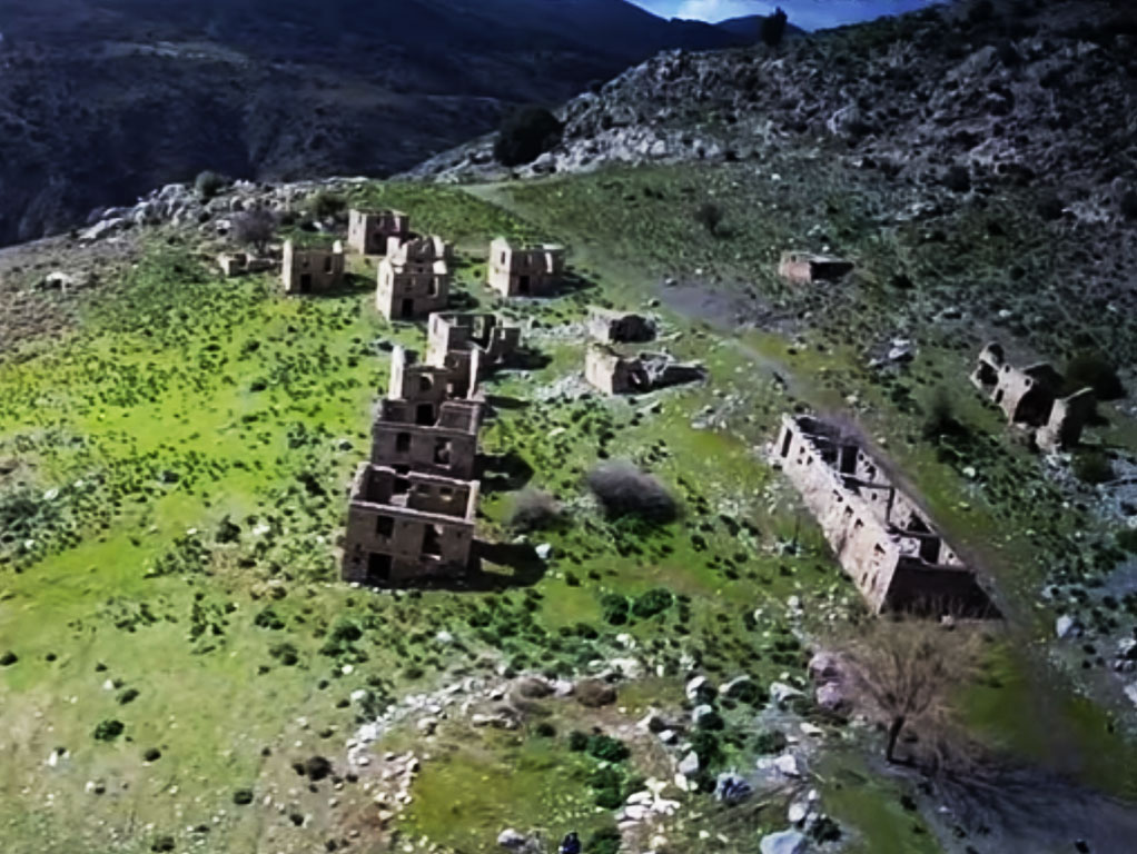
11. Nea Vorizia
Nea Vorizia is a ghost village on the southern slopes of mountain Psiloritis between the villages of Zaros and Vorizia, below the historic Monastery of Vrontisiou . An abandoned village for decades with its own history that goes back to the years of World War II.
During the Nazi occupation the people of the village took part in the Greek Resistance. On August 15, 1943, a bloody battle took place at the nearby site of Trachili, between the rebels of Petrakogiorgis and the German troops, where the Germans suffered significant losses. As revenge, the Germans, a few days later, on August 26, executed many residents, burned the village, bombed it, destroying it completely and forced the last habitants to abandon the place.
After the liberation, the Ministry of Reconstruction built a new village at a short distance from the ruined village in order to relocate the residents who had lost their homes. The new village was named Nea Vorizia but was never habited as the residents chose to build their houses on the ashes of the old village. The new village with the ruined houses still stands there to remind the new generations those years.

12. Vryses Crete
Vryses is a popular tourist destination that has maintained its Cretan character. The picturesque village, is built at the foot of the Lefka Ori (White Mountains) in a valley with lots of greenery and running water. It is located 32 km from the center of Chania, in the midway between Chania and Rethymnon and is at the start of the road leading to Chora Skafion. The permanent population is mainly occupied in citrus growing and olive oil production.
The village is crossed by three rivers: Boutakas, Vrysianos and Farmakera. The rivers Boutakas and Vrysianos merge in the center of the village, next to the bridge of 1942. The village is well known for the traditional coffee shops beneath the plane trees at the centre of the village as well as for its delicious goat cheese and its local sheep’s yogurt.
Athough Vryses is a new village dating back to 1925, archaeological findings have demonstrated that there is continuous human presence in the area since the Neolithic period (6000 to 3000 BC). In short distance there were the ancient cities of Amfimalon and the ancient settlement of Filippos. During Hellenistic times, an arched bridge, known as the Kamara, was built on the Boutaka River. The area where the arch is located is full of Minoan and Roman shells and plinths of Roman times, probably box-shaped tombs.
The two big traditional festivals of the village take place on July 7th and on the 15th of August. Visitors have the opportunity to see a traditional Cretan feast and taste local delicacies.

13. Loutro
Loutro lies on the south coast of Chania, at the end of Cape Mouri. It is situated between the villages of Chora Sfakion and Agia Roumeli, 70 km away from the city of Chania. The small, picturesque village is enclosed in a sheltered cove at the entrance of which there is a tiny rocky islet. Most of the people are involved in tourism and in fishing.
Loutro doesn’t have any roads hence there are no cars. The village was named after the baths (Loutro bath in Greek) found in the area, and from which water was directed to nearby village of Anopolis. The whitewashed buildings with the blue windows and the pink blossomed bougainvilleas resemble a Cycladic village. The stunning color of the sea, is one of those things that have made this village famous. Loutro can be reached only by foot or by sea. There are daily ferries connecting the village with the nearby ports of Chora Sfakion, Sougia, Paleochora and Agia Roumeli.
Loutro is the site of the ancient city of Phoenix (Finikas). Phoenix was the port of the ancient town of Anopolis. It later served as a wintertime port of the town of Sfakia. The tiny village is quite easy to explore on foot. There are some very nice buildings to see, such as the Government House that was used during the Greek Revolution in 1821 and the Byzantine church of the Archangel Michael. It is also worth visiting the Venetian castle on the hill above the village.
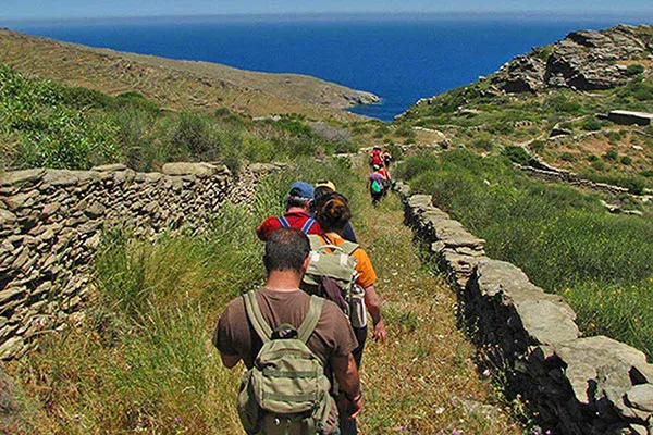
The picturesque village is a heaven for hikers. There are several nice walks in the area, surrounded by spectacular nature and unspoiled mountain countryside. The coastal path E4 connects Loutro with Chora Sfakion on the west and Agia Roumeli on the east. From the center of the village, you can follow the path leading to the beautiful chapel of St. Catherine in Anapolis. From Loutro you can also explore the gorge of Aradena, Imvros gorge and of course the great Samaria gorge.
Due to its isolated location, it is an ideal destination for those who want to destress and relax away from the pace of the city. In Loutro there is notghing to do but eat, drink and laze. The village has a pebbly beach with crystal-clear green water. In short distance there are the magnificent beaches of Glyka Nera, Perivolakia, Timios Stavros, Foinikas and Marmara.
In Loutro you can find markets, taverns, restaurants, coffee shops and of course several hotels and rooms to let. If you want to take advantage of the warmer sea at the end of the summer and get rid of the high season crowds, it’s a wise idea to visit Loutro in September.
.jpg)
14. Koutouloufari
Koutouloufari is a traditional village, at the northern slope of mountain Pyrgias, 28.9 km east of the city of Heraklion. In the list of the villages of Crete by Fr. Barozzi of 1577 is referred to, as Catafari metochio and in the catalog of Basilicata as Cutrufari. The Cretan village with its stone-paved narrow streets and the old stone-built houses amphitheatrically built, offers beautiful view to the Cretan Sea. Picturesque corners, arches and beautiful inner courtyards roofed with vines offering shade and grapes in summer are an excellent example of Cretan folk architecture.
One of the main attractions of the village is the church of Agios Vassilios with the wood-carved iconostasis, built on the ruins of an older church of the 14th century. In the traditional cafes and tavernas you can taste the Cretan cuisine under the shade of the vines and relax drinking a Cretan raki, the most popular drink on the island. The area where it is located offers a variety of choices: beaches, entertainment, sights and archaeological sites such as Knossos and Malia. The beautiful village with its hospitable inhabitants has become a popular tourist destination enchanting the visitors with its simplicity. During the summer, Cretan nights and various other cultural events are organized by local cultural groups, attracting many tourists. Koutouloufari is the ideal destination for those who want to relax staying in a quiet and picturesque place.

15. Maroulas Rethymno
Maroulas is a traditional village, located 10 km southeast of Rethymnon. Built on the top of a hill, offers panoramic views of the valley and the Cretan sea. Maroulas is a quite village with buildings dating back to the Venetian period, surrounded by greenery, a spring and several valleys. The village is classified in Class II, that is of average cultural value as it retains its architecture and other Venetian characteristics. According to tradition, Maroulas took its name from the shepherdess Maroula, who, while grazing her sheep in the region, found a spring of cool digestive water.
It dates from the Venetian period back in 1577. The surviving buildings retain the special architectural features of that time, such as loopholes, coats of arms, impressive doors and arches. Amongst its rich historical heritage, there are two wonderful towers, one of which is 14 meters high, a Byzantine church dedicated to the Ascension and a couple of more churches. The landmark of the village is the imposing tower of Maroulas of the 16th century. The tower which served as an observation point, was recently renovated and has three floors. In 1630, the Turks settled in Maroulas and used its two towers as fortresses.
However, it is probable that the area was inhabited during the Minoan period. This is testified by the findings of the two cemeteries of the palatial period that have been revealed in the area. The first was found at Mezaria while the second at Prinares. The findings of both are exhibited at the Archaeological Museum of Rethymno.
Venetian towers, cisterns, narrow paved alleys, arches, arched doors and historic chapels takes you back in time, in the middle age, the Renaissance and the years of the Turkish occupation. One of the main attractions is the Church of the Prophet Elias at the top of the hill, with extensive views of the traditional village and the Cretan Sea. Every year on July 20, a big feast is organized in honor of the Prophet Elias. Other sights worth visiting are the barracks used by the guards, the buildings complex “Metohi” with distinct elements of Renaissance and Muslim style and of course Vryssi, the natural spring of the village. The water of Vryssi is not drinkable, but you can rest under the shade of the big plane tree. It is also worth visiting the picturesque square of the village and spend a pleasant time with the locals.
In the 1980s, the village suffered great migration but nowadays many people return back. There are also many foreigners who moved to the village permanently. The village attracts many painters and photographers as it offers a variety of themes. In Maroulas you can find some tavernas and cafes.
Protected Historical Monument - ΦΕΚ 1226/Β/25-11-1980

16. Sissi Crete
Sisi (or Sissi) is a traditional fishing village on the north coast of Crete. It lies in a fertile plain near Malia, in the prefecture of Lassithi at the border with Heraklion. The village has developed around a lovely natural and protected cove, resembling a large swimming pool, which serves as an anchorage for the boats of the local fishermen. From its port several boat excursions are organized to beaches and villages in the surrounding area.
Sisi has experienced great growth in recent decades as a result of which it has become a popular tourist destination. Today its economy is based on the cultivation of olive trees and the production of olive oil as well as tourism. Life in Sisi is different than neighboring Malia or nearby Hersonissos as it flows at a much easier and calmer pace.
The village retains some of the features of the past with no enormous buildings, and some beautiful streets decked with blooming bougainvillea. In the narrow alleys and along the coast, traditional fish tavernas facing the beautiful harbor serve fresh fish and local Cretan delicacies to visitors.
There is a lack of good beaches inside the village itself due to the steep rocky coast but there are a few nice beaches such as Boufos and Avlaki at a short walk towards the direction of Milatos. Thus, the only beach in town you can swim is the small beach located inside the harbor which is well protected by waves. The area is vulnerable to northern winds and the sea is often rough. On the hill Kefali or Kremasma, located between the two beaches, a Minoan settlement and a cemetery have been discovered, proof that the area has beem inhabited for thousands of years. During the Cretan Revolution (1866-1869), Sisi was a strategic spot for unloading guns and munitions for the Lassithi rebels.
It is situated 41 km from Heraklion, 8 km from Malia and 26 km from Agios Nikolaos. Its geographical location makes it an ideal destination as it can be the basis for exploring the central eastern part of Crete. The area is rich in history and beauty so there is much to see and experience. Worth visiting sites in nearby areas are the monastery of Saint George of Selinaris with its 16th century church, the picturesque village of Epano Sisi and the traditional village of Vrahassi, built on the slopes of Mount Anavlochos. The village also offers hiking paths in the area and places to ride bicycles.
Sisy offers all kind of accommodation, even campsites. In the town you can find various stores and services that cover every need. As it is away from the main road there are only very few public buses a day and if you want to move around it is best to have a car.

17. Piskopiano
Piskopiano is a small traditional village, close to the magnificent coast of northern Crete. Perched on the slopes of Mount Harakas, it lies between two other, equally beautiful villages, Koutouloufari and Ano Hersonissos and offers panoramic views of the cosmopolitan beach of Hersonissos. Piskopiano seems to have been built during the Middle Ages when pirate raids forced the residents of the area to find protection away from the sea. The village was first mentioned in a book back in 1379 as part of the Great Episcope of Hersonissos.
There is not much to do in Piskopiano, rather than to wander around the enchanting narrow streets and alleys with the stone-built whitewashed houses with the little flower pots on their windows. The place reflects the tradition and beauty of old Crete and is a typical sample of Cretan architecture. There is also a small but remarkable Agricultural Museum with lots of exhibits related to agriculture and rural life of Crete, including a wine press, olive oil, carpentry, weavings and many more items.
Piskopiano is an ideal place for relaxing holiday, but at the same time, close to many interesting places to visit, many of which within walking distance. So, if you would like to be away from the bustling nightlife of Hersonissos but still close enough, then Piskopiano is a great choice. It offers traditional tavernas, cafes and accommodation of all prices and categories. The village is situated 2 km away from Hersonissos harbor and 26 km away from the city of Heraklion.

18. Agia Roumeli
Agia Roumeli is the small village at the end of the Samaria National Park. This is a fairly new village as the Old Agia Roumeli was located about 2 km north, right at the mouth of the gorge. In 1954, heavy rainfall made the river flood, causing great damage to the village which was then relocated to its present location near the coast. Today, the ruins of the old houses stand alongside those restored by their owners. Located between the ravish blue Libyan Sea and the steeply towering cliffs of Lefka Ori (The White Mountains), the remote village is an ideal destination to relax away from cosmopolitan resorts and crowded beaches.
The village is built at the site of ancient Tarra, a small yet powerful city that flourished during the Roman era. The ruins of the Temple of Apollo (or Artemis) are still visible. At this point you can also visit the old church of Panagia (Virgin Mary) built in 1500. Walking along the shore towards the east, you will find the ancient Byzantine chapel of Agios Pavlos, where according to tradition, St Paul landed and baptized Christians. On the hilltop above Agia Roumeli stand two ruined Turkish fortresses. The first, is not particularly hard to reach and offers amazing view of Agia Roumeli and the endless blue of the Libyan Sea, interrupted only by the islands of Gavdos and Gavdopoula. The other castle is in a poor state, the path is uphill and requires you to be in good fitness. Finally, on the eastern edge of the gorge, near the exit, you can visit the quaint chapel of Agios Antonios (St. Anthony), built in a cavity, shaped in the rocky walls.
Is not so easy to reach Agia Roumeli because there are no roads leading to the village. But this is also what makes this place so special. The only way to reach the village is either on foot through the Gorge of Samaria or by taking one of the boats from Hora Sfakion, Sougia, Loutro or Paleochora. You should know that Agia Roumeli does not have a safe harbour, only a small jetty, making it hard for ferries to dock when the weather is bad. This means that there are no trips and you may be cut off in Agia Roumeli for one or two days. Hiking lovers and more adventurous visitors can also take the trail from Chora Sfakia to Agia Roumeli (approximately 7 hours).
The village is getting busy during the summer season due to the visitors coming down the Samaria Gorge, and waiting for the boat to take them to Sfakia (Chora) or Paleohora. There is a good choice of hotels and rooms to rent and some taverns. After a few hours of hiking it is a pleasure to sit in one of the taverns and enjoy homemade traditional food and some good wine.
The beach which is right in front of the village extends for almost 3 kilometers east. It has fine pebbles and clear deep blue waters. Umbrellas and sea beds are available close to the dock. For those who want to dive or snorkel, there are cliffs and rocks at the western end of the beach. On both ends of the bay, there are other pristine and isolated beaches, well-hidden by rock formations. If you stay long enough, then we strongly recommend to hire a boat or canoe and visit the gorgeous and secluded beaches of the area, Domata, Fournoti and Kalogiros.

19. Samaria
Nestled within the awe-inspiring Samaria Gorge in Chania, Crete, the now-abandoned Samaria Village is a fascinating historical stop along one of Europe’s most famous hiking trails. Once home to woodcutters, the village was evacuated in 1965 when the gorge was designated a National Park. Today, it serves as a popular resting point for hikers, offering restroom facilities and a glimpse into Crete’s rich past. Some of the old stone houses have been repurposed for park staff, preserving the village’s traditional charm.
A Village Steeped in History
The village and the gorge take their name from the Church of Osia Maria the Egyptian, a small yet historically significant chapel located just outside the settlement. Dating back to 1379, this Byzantine-era church is adorned with remarkable frescoes and celebrates its feast day on April 1st.
During the Ottoman era, Samaria Village served as a refuge for Cretan revolutionaries and locals seeking shelter. However, one of its most notable historical moments came in 1941, during World War II. The King of Greece, George II, along with Prime Minister Emmanouil Tsouderos and other government officials, sought refuge in the village before fleeing to the Middle East. It was in one of Samaria’s stone houses that the last official order on Greek soil was issued, calling for continued resistance against the German invasion.
A Must-Visit Stop on the Samaria Gorge Hike
If you’re hiking the Samaria Gorge, be sure to take a break in this abandoned village. Wander through the deserted stone houses, admire the traditional Cretan architecture, and visit the historic Church of Osia Maria. It’s the perfect spot to rest, take in the breathtaking surroundings, and immerse yourself in Crete’s rich history before continuing your adventure toward Agia Roumeli and the Libyan Sea.